
Modeling the Spatiotemporal Evolution of the Impact of Flooding and Erosion on Dikes and Infrastructure in Kamouraska (MOSÉKA)

Programme de recherche en partenariat dans le secteur maritime I - FRQ
Description
The Kamouraska aboiteaux represent a unique agricultural and cultural heritage in Quebec. Built in the early days of colonization to convert coastal marshes into productive farmland, these structures continue to play an essential role today in protecting communities, infrastructure, and farmland from coastal flooding. Nearly 35 km of dikes alone protect villages, key roads such as Route 132 and Highway 20, and thousands of hectares of farmland.
However, rising sea levels, more intense storms, and reduced ice cover in the St. Lawrence Estuary are increasing the risk of flooding and putting these aging infrastructures to the test. In this context, the MOSÉKA project aims to better understand the current and future vulnerability of the areas protected by aboiteaux in order to support adaptation decisions and strengthen the resilience of the Kamouraska coastline in the face of climate change.
Problematic
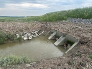
Recent events in the St. Lawrence Estuary demonstrate that coastal risks are on the rise. Major storms, such as those in 2010, Dorian (2019), Fiona (2022), and Debby (2024), have caused significant storm surges and revealed the vulnerability of several protective structures. In Kamouraska, some aboiteaux already exhibit weaknesses related to aging, the erosion of the coastal marshes that naturally protect them, and the increasing frequency of extreme weather events.
Despite the strategic importance of these infrastructure systems, there are currently few tools available to accurately assess their performance under future conditions that include sea-level rise, extreme waves, and concurrent river flooding. Decision-makers must, however, choose among various adaptation strategies: raising structures, restoring natural habitats, land-use planning, or risk management measures.
The challenge, therefore, is to develop an integrated scientific approach capable of accurately modeling coastal flooding mechanisms and assessing the effectiveness of various adaptation solutions in a context of climate uncertainty.
Objectives
- Gather new data on meteorological and marine conditions, topography, and bathymetry along the coastline;
- Define extreme weather scenarios that incorporate tides, storm surges, waves, and sea-level rise;
- Develop and validate a hydrodynamic model of coastal flooding that takes into account floodgates and levees;
- Simulate the overflow of structures and the spread of flooding under various future scenarios;
- Evaluate and compare adaptation strategies, whether structural (raising structures) or based on land-use planning and nature-based solutions.
Case Study: The Aboiteaux of Kamouraska
Kamouraska serves as an exceptional testing ground for studying coastal flooding risks. Its network of dikes protects communities, essential transportation infrastructure, and a large area of low-lying farmland. These structures, the legacy of several centuries of land-use planning, now represent one of the main lines of defense against tidal flooding in the middle St. Lawrence Estuary.
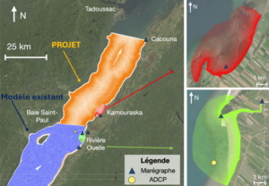
The project will focus its analyses on several vulnerable areas, including Rivière-Ouelle, Saint-Denis-de-la-Bouteillerie, Saint-André, and Kamouraska. Field measurement campaigns will provide new data on water levels, waves, currents, bathymetry, and the condition of structures. This data will feed into a high-resolution numerical model capable of simulating current and future extreme events.
The results will help identify the areas most at risk, assess the potential consequences of flooding, and propose solutions tailored to local conditions. MOSÉKA will thus contribute to the long-term protection of communities, infrastructure, and natural environments along the Kamouraska coastline, while strengthening the region’s resilience to climate change.
Abair, S., J. Noman, S. Daniel, A. Hammouti, D. Pham Van Bang, 2026. Strengthening Coastal flood forecasting through event-based data capitalization: a case study from the December 2022 storm surge in Québec city. Natural Hazards, Vol. 122-30, https://doi.org/10.1007/s11069-025-07780-5
Le Mouel, M., P. Matte, A. Hammouti, D. Pham Van Bang, 2024. Investigation of 3D circulation and secondary flows study of the Saint-Lawrence fluvial estuary at a tidal junction, Estuary Cont. Shelf Sci. (in press), https://doi.org/10.1016/j.ecss.2024.109058
Don’t just coexist with climate change.
